While rummaging around a Wisconsin junk shop in the mid-1990s, I found a map of occupied Tokyo. Dated April 1947, it was printed by the US Army’s 64th Engineer Topographic Battalion, which produced critically important maps for wartime and postwar military operations, especially in Asia.
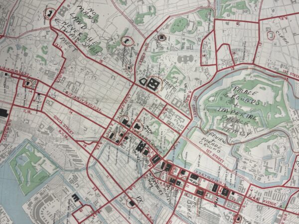
Photo: Steven P. Remy
This one was designed to help thousands of American personnel and their dependents navigate the sprawling, bomb-scarred city. The 22-by-29-inch map folds neatly to pocket size and centers on the area between the Imperial Palace grounds and Tokyo harbor, encompassing Chiyoda special ward, the Ginza district, the main train station, and the financial district. Here the Americans established the administrative, residential, and social infrastructure of the occupation, its landmarks highlighted in solid black: General Douglas MacArthur’s headquarters, the embassy, hospitals, banks, post exchanges, vehicle maintenance shops, cinemas (one named for war correspondent Ernie Pyle), apartment buildings, hotels, and clubs. Known as “little America,” its streets were jammed with jeeps, buses, and imported American cars and its buildings festooned with American flags and—every December—covered in Christmas decorations.
A web of bright red lines indicated bus routes servicing the area, with a few extending to peripheral points of significance, notably the former war ministry building then housing the International Military Tribunal for the Far East. Werner Michel, an army intelligence agent, recalled the map—which he carried along with one of the city’s wards and police boxes (“where a policeman could assist by pointing to the desired location often in pantomime”)—made getting around “an adventure.”
While copies of the map are not hard to find today, what’s most intriguing about the one I found are the personal notations of the original owner. He is not identified, though he left some clues. “Work” is written next to a circle drawn around the Bank of Chosen, the central bank for Japan’s Korean colony until 1945, when the Americans took it over for a similar purpose in the US-occupied south. “Billet” is written next to the finance ministry. “E[nlisted] M[en’s] club” is also noted. In a nod to the emerging Cold War, the roughly one kilometer between the Soviet and American embassies is designated “No man’s land—never the twain shall meet.”
It’s also clear he had an active social life. “Oh boy!” appears next to the YWCA and “WAC shack” next to the Women’s Army Corps headquarters. The names of 16 women are indicated at various points, usually next to a hotel or office: Nannette at the French embassy, Soo Fen at the Chinese. Only one name, Kimiko, is Japanese.
In stark contrast to the lives of most Japanese people, that of an American in the enclave was indeed something of an adventure, and an extraordinarily comfortable one. In a city in which 65 percent of the housing stock had been destroyed, thousands of Americans lived in intact apartments and hotels or in spacious homes attended to by multiple Japanese servants, their wages paid by the Japanese government. The entertainment venues and commissaries—off-limits to Japanese—were numerous and well stocked. And while many Americans were compassionate and respectful, MacArthur’s personal interpreter later admitted that MacArthur and nearly every other American he knew “were extremely conceited and extremely arrogant and used our power every inch of the way.”
In simple graphic form, the map reflected the harsh reality of the occupation. The assortment of requisitioned offices, hotels, and recreational facilities stands in sharp contrast to the pale, unmarked stretches outside little America. As the wife of an American officer remembered, much of that space would have been “wasteland, heaped with ashes, charred wood, and rusty metal,” places even adventurous Americans rarely visited.
Steven P. Remy is professor of history at Brooklyn College and the Graduate Center, City University of New York.
This work is licensed under a Creative Commons Attribution-NonCommercial-NoDerivatives 4.0 International License. Attribution must provide author name, article title, Perspectives on History, date of publication, and a link to this page. This license applies only to the article, not to text or images used here by permission.