 The Visible Past Project uses a wiki, Google Earth, and even a CAVE (Configurable Automatic Virtual Environment), to teach history in a whole new way: “using visual interfaces”. Users locate a “virtual, real, [or] mapped” point and then find information about that point.
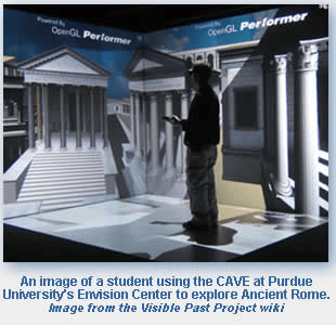
Sorin A. Matei, associate professor of communication, developed the Visible Past Project with a team from Purdue University. In a recent video interview with the Chronicle of Higher Ed, Matei demonstrated how he uses the Purdue’s Envision Center CAVE to allow students to virtually walk through the Roman Forum (created digitally by UCLA and the University of Virginia).
Online, the Visible Past Project can be accessed through its “Gwiki,” which combines the wiki medium with Google Maps and Google Earth. Users click on a point on a Google map and information for that point comes up through the wiki. And as is traditional with wikis, this information can then be added to or edited by those who visit the site.
To learn more about the Visible Past Project, and this new take on teaching history, check out their online demo, or visit the main Visible Past web site.
This post first appeared on AHA Today.