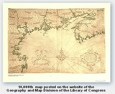
Samuel de Champlain’s 1607 map of the North American coast from Massachusetts to Nova Scotia
The Geography and Map Division of the Library of Congress recently reached a milestone of sorts, with the posting of its 10,000th map online. Ten years after starting its map digitization project, the Geography and Map Reading Room posted Samuel de Champlain’s 1607 map of the North American coast from Massachusetts to Nova Scotia. As their web site explains, “the unique document, originally intended for presentation to Henry IV, King of France, was compiled by Champlain (1567–1635), founder of New France (Canada). The map provides the first thorough delineation of the Canadian and New England coast from Cape Sable to Cape Cod.” The map first came to the Library of Congress in 1915 by bequest.
The Geography and Map Division of the Library of Congress is the largest collection of cartography and geography resources in the world. Its collection includes 5.4 million maps, 75,000 atlases, and 500 globes. The 10,000 maps that have been digitized since 1996 can be found on their Map Collections web site. Map Collections is organized according to seven major categories (“Cities and Towns,” “Conservation and Environment,” Discovery and Exploration,” “Cultural Landscapes,” Military Battles and Campaigns,” “Transportation and Communication,” and “General Maps”), and is browseable by geographic location, subject, creator, and title, or searchable by keyword.
This post first appeared on AHA Today.